Location: Parallel to northeast side of Route 2, off Newtown Road, near Littleton boundary
Loop trail: 0.7 mile
Acreage: 47
Terrain/Trail Conditions: Gently hilly terrain; mostly dry walking conditions, except on a short section along the gas line easement that parallels Route 2.
Entrance:
- From Bulette Road (off Newtown Road). Look for signage and entrance gate on the left approx. 200 ft. from the end of Bulette Road. Parking at/near end of road (please be careful not to block private drives). Kiosk at end of access trail, one quarter mile from entrance gate.
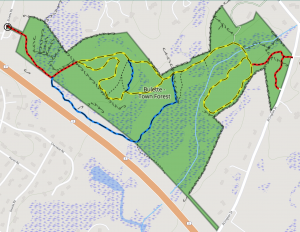
Bulette/Town Forest Conservation Land includes 22 acres of Town Forest (the smaller of two such tracts in Acton). The remainder of the acreage is wetlands, and, except for a glacial esker along which a secondary trail allows viewing of the marsh, this portion is unsuitable for trails. Most of the Town Forest acreage is upland woods, predominantly oak and white pine enhanced by a scattering of beech trees, and it is this area that the trail system covers.
The trail system’s moderately long red access trail leads to a yellow loop trail, which is bisected by one blue secondary trail and an unblazed portion of fire road. The red access trail is a fire road passing between wetlands on the east and, on the west, large slabs of cut rock and boulders remaining from the construction of Route 2. Shortly after taking a sharp easterly turn, this access trail crosses a tiny tributary of the Grassy Pond Brook and then passes through a stone wall, where it intersects the yellow loop trail. The information kiosk is located at this intersection. The trail system also includes a second blue trail, outside the main loop trail, that follows the top of an esker that separates the upland from the marshy area in the property’s southeastern portion.
From the kiosk, a hiker can continue eastwardly along the yellow loop trail, a portion of which serves as a fire road. Alternatively from the kiosk, a hiker can head southeast onto the loop trail to follow a narrow footpath that winds through attractive upland forest conspicuously dotted with large boulders and rocky outcrops present throughout the upland area.
The northerly portion of the loop trail continues eastwardly to a junction where the fire road turns south and a blue crossover trail begins, going southeasterly. At this junction the yellow loop trail heads due east onto a narrower forest path, soon turning southeasterly and going downhill into a graceful wooded basin with lovely ferns throughout. The fire road south of the junction is represented on the map as an unblazed dotted track.
Within the loop, and paralleling the fire road, the seemingly redundant blue crossover trail allows a hiker to traverse the rim of a small escarpment that overlooks the lower basin through which the loop trail passes. Lovely views, as well as interesting rock outcrops, may be seen all along this trail. Some of the rock is geologically very ancient.
At the most easterly point in the basin, where the loop trail turns west, the blue esker trail leads off to the east and then south. It passes along the top of the esker until it smoothes out into the edge of the southern wetlands. After crossing a damp area, the trail turns northwest, crosses the Grassy Pond Brook tributary stream and, following a gas line easement that parallels Route 2, eventually joins the access trail. Though the distances along most of these trails are short, the views and interesting terrain make all trails well worth the walk. No other parcel among the Acton conservation lands has rock formations so attractively situated within lovely woodland.