
Location: North Acton, north of Great Road (Route 2A) and Harris Street, west of Main Street (Route 27)
Terrain/Trail Conditions: Mostly level with minor ups and downs, particularly near Quarry Road; varying trail conditions, from twisting, stony woods paths to wide, smooth trails that include some segments with crushed stone, wood chips, or asphalt surfaces
Loop trail: 1.9 miles
Acreage: 90
Entrances:
- End of Nagog Park Drive, off Great Road (Parking, Kiosk)
- West side of Quarry Road, off Main Street (2); first is across from NARA amphitheater entrance (P), second is across from Miracle Field (P, K)
- East side of Captain Handley Road, immediately off Harris Street (P, K)
- End of Sachem Way, off Great Road
This conservation land comprises Wills Hole Conservation Land and the contiguous Town Forest. Its most unusual feature is Wills Hole, a pond and quaking bog ecosystem in the westerly portion. The easterly portion, much of it strewn with rocks and boulders, includes 49 acres designated as Town Forest where town residents once found firewood in stands of red and white oak, red maple, and white pine.
The property’s yellow loop trail can be reached by six red access trails. One blue secondary trail cuts through the central and northern part of the loop. An unblazed pedestrian walkway, packed with crushed stone, passes between NARA and the Nagog Park Drive entrance, outside of which overflow parking is available for NARA events.
The Nagog Park Drive entrance provides the most direct route to the Wills Hole pond and bog. Heading south from this entrance (counterclockwise on the map), the loop trail follows the top of a glacial esker, a sand and gravel ridge deposited by a stream that flowed beneath a melting glacier. The curving form of this narrow, raised landform with steeply sloping sides signifies its glacial origin. Below the esker on both sides are flat, shrub-filled bog and wetlands areas, extensions of the Wills Hole habitat.
The esker is a drainage divide: Water on its east side flows into Nonset Brook; water on its west side flows southward to Wills Hole Brook. Both streams eventually empty into Nashoba Brook. The esker ends at a small hill covered with an old grove of white pines. Immediately to the west is a 170-foot boardwalk that leads to the edge of the open water of the Wills Hole pond. Educational panels provide information on the Wills Hole ecosystem.
Wills Hole is a classic quaking bog. At its center is an open pond. Ringing the open water is a mat of floating sphagnum moss. The moss, in turn, is ringed by a slightly upland zone of dense shrubs and trees. These include black spruce, larch, and swamp azalea.
Quaking bogs are unusual environments that support unique plant life because the bog waters are typically acidic and poor in the nutrients that most plants use. The result is the growth of carnivorous plants that, to obtain needed nutrients, trap and digest insects and small animals. Plants of this type at Wills Hole include the pitcher plant and the sundew. Noncarnivorous plants on the sphagnum mat include American cranberry, leatherleaf, sheep laurel, and swamp loosestrife. All these plants can be observed from the boardwalk. Visitors should stay on the boardwalk and not step onto the fragile bog mat.
Beyond the white pine grove at the end of the esker, the loop trail continues its circuit of the property, passing the Sachem Way access trail on the right. The trail turns east, and then northeast at the access trail from Captain Handley Road, close to a subdivision on Alexandra Way. It then runs downhill on an asphalt surface, heading towards NARA. Here one can see occasional jumbles of large boulders, evidence of old granite quarries that, for the most part, are now privately owned by a resident sculptor.
After crossing a driveway, two short trails provide access from Quarry Road and NARA. North of this, the blue secondary trail leads off to the west, offering a secluded walk through the central part of the forest where, looking closely, one can see old metal quarry-crane anchors embedded in boulders. The loop trail then meets the third short access trail from Quarry Road and NARA’s Miracle Field. Further on, the loop trail crosses the NARA pedestrian pathway, passes the northern end of the blue trail, skirts a wetlands area with a tiny pond, and completes the circuit back at Nagog Park Drive.

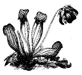 Northern Pitcher Plant (Sarracenia purpurea)
Drawing by Heather McElroy
Wills Hole Map (full screen online map)