A History of Camp Acton – 1955 to 1997
By Vahram “Vee” Sookikian
The property known as Camp Acton off Pope Road in the northeast portion of Acton was deeded to the former Sachem Council, Boy Scouts of America, located in Arlington, Mass., by the will of Eleanor E. Whitcomb, dated Jan. 18, 1955. The land was described as about 5 acres of tillage and 55 acres of woodland and being the same land conveyed to her for $2500 through probation by deed of Marie C. Larson of Concord, Mass., dated March 31, 1939 and recorded with Middlesex South District Deeds, Book 6283, page 334, to it and its successors and assigns forever. Prior to 1939 the last land transaction of the subject parcel was on September 10, 1903 when the land was conveyed by deed from Charles Melvin of Concord to Andt Larsen, recorded with Middlesex South District deeds, book 3068, page 451.
In 1959 Sachem Council, with others along Route 128 merged to form Minuteman Council headquartered in Stoneham. In 1993 Minuteman Council would merge with the Boston Council to form the Boston Minuteman Council. This merger resulted in excess, short-term camp property and so in 1997 Camp Acton passed into the hands of the Acton Conservation Commission (ACC) with the provision that Boston Minuteman Scouts could camp there in perpetuity provided they first apply for a permit from the ACC and met basic requirements outlined in the permit.
When I first learned about Camp Acton in April of 1965 through Ray Shamel of Acton on the occasion of hiking the Capt. Isaac Davis Trail, I decided to investigate it as a potential camping site for my newly organized Troop 222, of Watertown, Mass, sponsored by St. 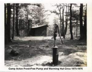 Stephens Church Men’s Club. That summer my troop and I explored Camp Acton for its camping possibilities. From the entrance on Pope Road an unpaved wagon road extended to a small parking area across from a 10’x12′ open shelter containing an iron stove and wall benches. Today only the chimney stands witness to the years of use by Scouts. Behind the shelter near the north boundary where a small brook sometimes runs, a small pond had been created by damming the brook behind and to the east of the shelter. The brook follows the north side of the farm road crosses southward under the road, and then the water runs along the southern boundary toward Pope Road collecting in a small swamp. From there it crosses under Pope Road and into the adjacent field on its way to become a tributary of Spencer Brook and of the Assabet River. From the artificial pond westward the brook made an ‘U’ turn through an opening in a n-s stone wall and then straightened out northward through the camp boundary wall continuing northward crossing the old road to Wheeler Lane and the Pauline S. Clayton Greene land to its source in the wetlands above the camp. To the west of the shelter and between it and another rock wall, heavy growths of juniper prevented the otherwise suitable camping area to be used as such. This overgrowth was cut out when tenting usage gradually increased between 1965 and 1970. Camping was initially confined to the parking lot area and the shelter. From here westward, the camp road continues through second growth pines which I estimate to be well over 100 years old from comparisons with growth rings I’ve seen on other pine trees this size. This area could have been the ‘5 acres of tillage land’ referred to in the turn of the century deeds. Beyond the pine growth hard woods take over including American Beech whose winter leaves glow golden on sunny winter days. About the half way point to the westward boundary with the ACC land the land rises being forced between rocky outcrops until it approached a wet place near the dogleg in the southern rock boundary of Camp Acton. At this point the farm wagon track disappeared from view. One could not tell which way it went under the heavy growth. Here, by good fortune, we met a surveyor who informed us that old maps showed the track continuing to a ‘Barnes Orchard’ thence to intersect the ACC trail. Having no luck finding the old wagon track we cleared out a suitable area just below the rising landscape and camped there for a number of years.
As word got out about Camp Acton being a fine primative camping spot more troops camped near the shelter and parking lot but gradually moved westward as the juniper was cleared. Campers built a small rustic bridge across the stream behind the shelter and the dam was added to until substantial water would build up in the pond area. At that time there was enough water flowing to provide good foot bathing for sore and tired feet. The council would hold adult leader training sessions at Camp Acton in the form of show and tell stations and the shelter would serve at those times as staff headquarters. The lack of a large open activity field near the shelter was a distinct disadvantage. About the end of the ’60s the Tennessee Gas Co. laid a natural gas pipeline across the access road in a rough N-S direction. The trench was a good 10 feet in depth and width and the cleared right of way was about 50 feet. This then provided parking on the right of way leaving the upper parking lot for activities. This attracted more troops and district camporees were now possible.
It was now in the early ’70s and our troop was camping all four seasons. One early spring day we awoke to a light snowfall and standing in the farm road looking toward the overgrowth where the trail had vanished, we could clearly make out the wagon wheel ruts filled in by drifting snow and separated by ‘the spring crop’ of stones in the middle having been pushed up by frost heave. ‘Eureka’, Mother Nature had revealed the trail to us. Each subsequent season our troop would clear the overgrowth as the snow filled ruts were revealed until we arrived at a fork. The left branch led to Barnes Orchard, and thence through the west boundary wall merging with Spring Hill ACC Land. The right branch also went to the west boundary stonewall which ended in marshland some 300 feet further north from where the left branch intersected it. Walking the property lines in winter one finds the NW corner void of stonewalls for a distance of 200 feet on either side on account of marshland. Where there is marshland on this property, there are no stonewalls built through the wet area.
Barnes Orchard is a rough English acre as the sides measure about 200 feet. All four sides are bounded by stonewalls. Chimney stones and two cellar holes are witness to an early habitation. As explained to me by a Scouter whose grandfather lived in NH in the same cellar hole configuration to the one in the orchard: the first room to be built was put up fast with a wet cellar, i.e., not lined with stone. This room acted as shelter while the chimney was erected and a second cellar hole dug and lined with stones with the chimney being the common wall. The dry cellar had what looked like an outside entrance. “Now” he said, “if this is correct, we should find a surface well in front of the outside entrance and to save steps it would be between house and barn”. Sure enough we found a surface well but not the barn. Water in the well was within a foot of the surface. I had it tested by a lab and found it to be potable. “The kitchen would be above the dry cellar and closest to the fireplace”, he said. So we started digging in the corner so indicated where someone else had obviously been digging before us. There, among domestic shards, I found a clay pipe minus the stem. The size of the stem bore was 5/64ths”, which would place its manufacture between 1720 and 1750. If my measurement were off by plus or minus 1/64ths”, the earliest date would be 1680 and the latest 1800. Some time in-between these dates a pipe was smoked and ‘broked’.
Having pushed the main road to the back boundary it remained to mark the trails, open up campsites and make a map sketch. This job fell to my son Steven Sookikian who earned his Eagle Scout badge doing this. By 1974, 22 troop and/or patrol camping sites had been identified, trails marked with orange tin can tops and maps supplied to the Council. By 1970, during winter camping trips, we often parked on the plowed Spring Hill Road cul-de-sac and backpacked in along the ACC trail going cross lots and across the camp boundary to make our winter camp. In exploring the wet area behind our campsite we stumbled across a well-hidden gravestone incised “The Educated Horse”.
The same time we were exploring Camp Acton and opening campsites from 1965 to 1975, various Council study committees were making recommendations based upon projected needs. A report written in 1974 on the future of Camp Acton reviews past recommendations:
1) The area should be maintained and developed. (1965)
2) Enter into immediate negotiations to buy the 60 acres of farmland north of Camp Acton (also known as the Pauline S. Clayton Green Land). (1965)
3) Coordinate planning with Acton Town Planning Board. (1965)
4) Retain and expand Camp Acton to 200 Acres. (1965)
5) National recommendation: Camp Acton has the potential to acquire one property of at least 200 acres. Acquisition of the “Dairy” (Greene) property and land to the rear of the present boundary should provide a good short-term camping, training and day use area. (1969)
6) The Camping and Engineering Service of BSA had provided a schematic layout including the Greene Land showing a ranger station, a 4 acre pond, conference center, service buildings, parking, separate Cub and Boy Scout areas on 500 feet centers with all areas connected by a service road. In addition it is noted that Camp Acton has the potential of meeting the 200 acre plan particularly with ACC land serving as a buffer zone against adverse adjacent development and for hiking and conservation activities). (1972)
7) In 1973-1974 the council properties committee recommends: Retaining Camp Acton while enlarging it with the addition of the Greene property, putting in a water system, constructing a camp wide area, and fixing the road and parking lot.
In the meanwhile, by 1972, the Minuteman Council Executive Committee considered selling off one or more of the 4 redundant camps it had at that time including Camp Acton. But volunteer agitation and court hearings saved Camp Acton for use by another four generations of Scouts.
It wasn’t until September of 1974 that Mr. William Sawyer; Chairman of the Acton Board of Selectmen received notice from the Scout Executive of Minuteman Council of the long range plan for Camp Acton. Nine years had passed since the 1965 recommendation mentioned requiring the addition of 140 acres with 60 acres coming from the Greene (dairy) Land and the rest presumably with an agreement from the ACC for use of contiguous land for nature trails. Also in the Sawyer letter it was mentioned “numerous requests for camping facilities from units not only across America, but one troop from Great Britain, that are planning to visit the Boston area in 1975-1976”, therefore we planned on developing our Acton property to provide camping areas for troops that will be visiting our Council. Sawyer was told an affidavit of the approval for the above development had to come from the Chairman of the Board of Selectman of the Town in order to receive matching funds from the Massachusetts Bicentennial Commission.
The development included graveling the existing road and parking lot, digging a deep well and constructing a shower facility and service building. Five troop sites were to be developed on 500 foot center-to-center spacing with 15 to 25 boys camping plus adults. As a member of the Executive and knowing most about Camp Acton at the time I was asked to take charge of the development of Camp Acton with emphasis on the upcoming Bicentennial. Some time after the Sawyer letter I started approaching key people who would contact suppliers of gravel, trucks, ‘dozers and compactors and who would perform these services gratis. This takes much time and so no work was done in 1974.
In the meanwhile, a Bicentennial Celebration was planned for June of ’75 in Acton. An appropriate gateway was designed and erected at the entrance. This Celebration was the highlight activity of 1975 and that of the entire camp history. The program consisted of Colonial music, oral history of the times leading up to “The Shot Heard Around the World”, military demonstrations of musketry and tours of exhibition tents. The open shelter became HQ, kitchen and refreshment stand for the Colonial troops, the West Watertown Jr. High School fife and Drum band, and camp staff. A greased Liberty Pole was erected in the upper parking lot awaiting a red Liberty Cap to be placed there by any Colonial Scout who could negotiate the grease. Many young Colonials tried climbing the greased Liberty Pole but only one made it to the top to hang his red Liberty Cap.
Development work performed in 1975 consisted of drilling a 6-inch diameter well and installing a deep well hand pump in August of 1975 by A & W Artesian Well Co. of North Smithfield, RI for the sum of $1500. The well was sunk to 200 feet obtaining 8 gallons per minute. The road and parking lot was graveled and compacted by April of 1976. Acton Sand & Gravel donated materials. Ralph J. Salvucci provided a CAT D6, a compactor and arranged for a Gringeri flat bed. Manny Pazar of Vappi Construction made all the arrangements and Richard White and Sons provided 2-six-wheelers hauling 16 loads of sand and gravel totaling 150 yards. Tennessee Gas arranged to make sure the compactor did not cross the gas line. Plans were upgraded, now calling for an electric pump at the well to accommodate the expected flow for showers and flush toilets. This work was delayed an entire winter waiting the dry season of 1976 to perform the “perc” tests. In the meanwhile the 5 large troop sites had been located and cleared with the help of Scout troops. Acton’s Board of Health, Mr. Steven Calishman set down the requirements for the leaching field based on the percolation test results. He insisted we hire an experienced professional civil engineering firm to perform the “perc” tests. R.D. Nelson of Concord did the work on June 14, 1976 on the south side of the present site 2 where as he explained it, the glacier had dumped sand and gravel as a result of riding over the tops of elevated formations. Tests resulted in two pits producing 3.67 and 4.67 inches /min. at a depth of 48 inches and 54 inches respectively. All was set now to build the leaching field and toilets. But before any more work could be done, the Council Camping Committee ordered the work to stop not wanting to see the primitive nature of the camp despoiled. I retired from the project June 17, 1976.
Camp Acton was never developed beyond the well and road upgrade except for cutting down trees to enlarge camping areas. Nationally, Boy Scout membership continued to drop. Troops wanted to camp in new places now that gasoline rationing had ended. With the council merger in 1993 a whole new generation soon forgot about Camp Acton except for the older established troops who had a fondness for the place. The camp was never used by troops that visited the Boston Bicentennial Celebrations.
Vahram “Vee” Sookikian
Member at Large, Boston Minuteman Council, B.S.A.
August 29, 2002